![](/images/other/stat-length.png)
![Excursión A pie Schloß Holte-Stukenbrock - Rundwanderweg A9 - Photo](https://media.geolcdn.com/t/1900/400/578e171c-e1ff-4b2e-be2f-4ce980f02eb0.jpeg&format=pjpeg&maxdim=2)
Rundwanderweg A9
SityTrail - itinéraires balisés pédestres
Tous les sentiers balisés d’Europe GUIDE+
![Longitud](/images/other/stat-length.png)
Longitud
5,9 km
![Altitud máxima](https://static1.geolcdn.com/siteimages/upload/files/1508320355ic_sort_altitude_max_24dp.png)
Altitud máxima
129 m
![Desnivel positivo](https://static1.geolcdn.com/siteimages/upload/files/1508320355ic_sort_den_pos_24dp.png)
Desnivel positivo
39 m
![Km-Effort](/images/other/stat-length.png)
Km-Effort
6,4 km
![Altitud mínima](https://static1.geolcdn.com/siteimages/upload/files/1508320355ic_sort_altitude_min_24dp.png)
Altitud mínima
116 m
![Desnivel negativo](https://static1.geolcdn.com/siteimages/upload/files/1508320355ic_sort_den_neg_24dp.png)
Desnivel negativo
38 m
![Boucle](https://static1.geolcdn.com/siteimages/upload/files/16400158638029165_repeat_loop_refresh_sync_direction_icon.png)
Boucle
Sí
Baliza
Fecha de creación :
2022-02-11 14:09:31.879
Última modificación :
2022-02-11 14:09:31.879
![A pie](https://static1.geolcdn.com/sitytour/trail-icons/100.png)
1h27
Dificultad : Fácil
![Escanee este código QR para abrir la excursión en la aplicación SityTrail](https://capi.geolives.com/qq0zvz2zws4bq2lad0pu/sitytour/trails/3092102/qr.png?size=200)
Aplicación GPS de excursión GRATIS
A propósito
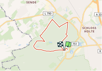
Ruta A pie de 5,9 km a descubrir en Renania del Norte-Westfalia, Kreis Gütersloh, Schloß Holte-Stukenbrock. Esta ruta ha sido propuesta por SityTrail - itinéraires balisés pédestres.
Descripción
Trail created by Heimat- und Verkehrsverein Schloß Holte-Stukenbrock.
Symbol: Weißer Text 'A9' auf schwarzem Grund
Localización
País:
Germany
Región :
Renania del Norte-Westfalia
Departamento/provincia :
Kreis Gütersloh
Municipio :
Schloß Holte-Stukenbrock
Localidad:
Unknown
Salida:(Dec)
Salida:(UTM)
472359 ; 5749922 (32U) N.
Comentarios
Excursiones cerca
![Excursión A pie Hövelhof - Rundwanderweg A5 - Furlbach – Rixelknapp - Photo](https://media.geolcdn.com/t/375/260/cd648ac5-5a1e-49b0-b1e7-22814812460e.jpeg&format=jpg&maxdim=2)
![A pie A pie](https://static1.geolcdn.com/sitytour/trail-icons/100.png)
Rundwanderweg A5 - Furlbach – Rixelknapp
A pie
Fácil
Hövelhof,
Renania del Norte-Westfalia,
Kreis Paderborn,
Germany
![](/images/other/stat-length.png)
3,3 km | 3,6 km-effort
49min
![](https://static1.geolcdn.com/siteimages/upload/files/16400158638029165_repeat_loop_refresh_sync_direction_icon.png)
Sí
![Excursión A pie Schloß Holte-Stukenbrock - Rundwanderweg A8 - Photo](https://media.geolcdn.com/t/375/260/578e171c-e1ff-4b2e-be2f-4ce980f02eb0.jpeg&format=jpg&maxdim=2)
![A pie A pie](https://static1.geolcdn.com/sitytour/trail-icons/100.png)
Rundwanderweg A8
A pie
Fácil
Schloß Holte-Stukenbrock,
Renania del Norte-Westfalia,
Kreis Gütersloh,
Germany
![](/images/other/stat-length.png)
6,1 km | 6,8 km-effort
1h 32min
![](https://static1.geolcdn.com/siteimages/upload/files/16400158638029165_repeat_loop_refresh_sync_direction_icon.png)
No
![Excursión A pie Schloß Holte-Stukenbrock - Rundwanderweg A7 - Photo](https://media.geolcdn.com/t/375/260/578e171c-e1ff-4b2e-be2f-4ce980f02eb0.jpeg&format=jpg&maxdim=2)
![A pie A pie](https://static1.geolcdn.com/sitytour/trail-icons/100.png)
Rundwanderweg A7
A pie
Fácil
Schloß Holte-Stukenbrock,
Renania del Norte-Westfalia,
Kreis Gütersloh,
Germany
![](/images/other/stat-length.png)
6,5 km | 7,3 km-effort
1h 39min
![](https://static1.geolcdn.com/siteimages/upload/files/16400158638029165_repeat_loop_refresh_sync_direction_icon.png)
Sí
![Excursión A pie Schloß Holte-Stukenbrock - Rundwanderweg A6 - Photo](https://media.geolcdn.com/t/375/260/578e171c-e1ff-4b2e-be2f-4ce980f02eb0.jpeg&format=jpg&maxdim=2)
![A pie A pie](https://static1.geolcdn.com/sitytour/trail-icons/100.png)
Rundwanderweg A6
A pie
Fácil
Schloß Holte-Stukenbrock,
Renania del Norte-Westfalia,
Kreis Gütersloh,
Germany
![](/images/other/stat-length.png)
5,9 km | 6,7 km-effort
1h 30min
![](https://static1.geolcdn.com/siteimages/upload/files/16400158638029165_repeat_loop_refresh_sync_direction_icon.png)
No
![Excursión A pie Schloß Holte-Stukenbrock - Sennebahn-Wanderweg - Photo](https://media.geolcdn.com/t/375/260/93194629-04fc-4922-a21d-074c55308d36.jpeg&format=jpg&maxdim=2)
![A pie A pie](https://static1.geolcdn.com/sitytour/trail-icons/100.png)
Sennebahn-Wanderweg
A pie
Fácil
Schloß Holte-Stukenbrock,
Renania del Norte-Westfalia,
Kreis Gütersloh,
Germany
![](/images/other/stat-length.png)
3,8 km | 4,1 km-effort
56min
![](https://static1.geolcdn.com/siteimages/upload/files/16400158638029165_repeat_loop_refresh_sync_direction_icon.png)
No
![Excursión A pie Desconocido - Rundweg Sennestadt - Photo](https://media.geolcdn.com/t/375/260/ext.jpg?maxdim=2&url=https%3A%2F%2Fstatic1.geolcdn.com%2Fsiteimages%2Fupload%2Ffiles%2F1545311037marcheuse_200dpi.jpg)
![A pie A pie](https://static1.geolcdn.com/sitytour/trail-icons/100.png)
Rundweg Sennestadt
A pie
Medio
Desconocido,
Renania del Norte-Westfalia,
Bielefeld,
Germany
![](/images/other/stat-length.png)
26 km | 30 km-effort
6h 45min
![](https://static1.geolcdn.com/siteimages/upload/files/16400158638029165_repeat_loop_refresh_sync_direction_icon.png)
Sí